


On the morning of Memorial Day, Monday, May 29, the Sedona-area Miller Fire is 31% contained at 30 acres and is experiencing minimal activity.
The Miller Fire was last reported at 35 acres but has been adjusted due to more accurate mapping.
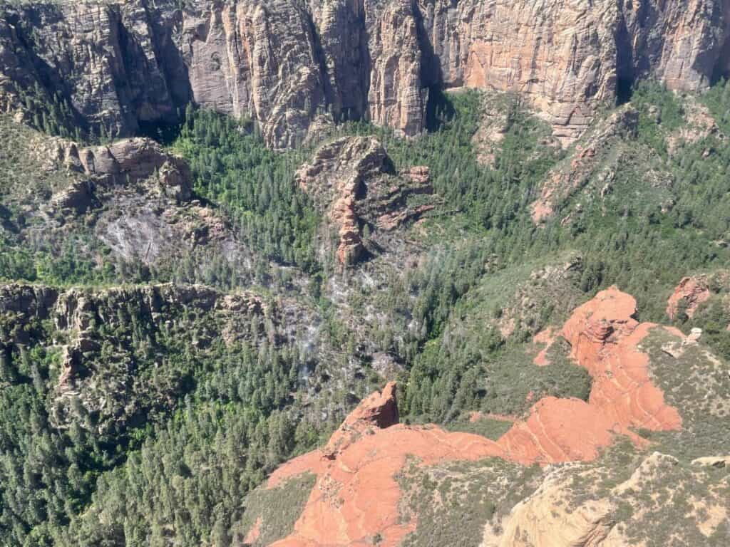
The lightning-caused fire is located in the Secret Mountain Wilderness of the Coconino National Forest’s Red Rock Ranger District (GPS coordinates: 34°57’21.2″N 111°50’05.6″W).
The Miller Fire is currently being managed by the Northern Arizona Type 3 Incident Management Team, which assumed control of the fire at 8 p.m. Friday. The team plans to transition management of the fire back to the Coconino National Forest 7 a.m. Tuesday, May 30.
A reduced closure order surrounding the fire area is being developed and will be posted Tuesday morning on the Coconino NF website. Forest visitors are reminded to check for area closures prior to any excursion and abide by all posted signage.
Current resources include one hand crew and one helicopter in addition to resource advisers and miscellaneous overhead.
Fire crews spent the last several days checking previously installed fire line along the south side of the fire in addition to aerially checking fire behavior.
Crews plan to install cameras and a monitoring system on the fire within the coming days so the RRRD can monitor fire behavior long-term, since hot spots are expected to persist in the area throughout the coming weeks due to high temperatures and weather conditions.
Though firefighters have not been inserted into the fire during the past three days, they have remained assigned to the fire in case an increase of fire activity dictates the need for further suppression efforts.
In addition to checking fire line, firefighters have spent the last three operational days scouting the area and collecting future intelligence regarding access routes, staging areas and helicopter landing sites. The information collected now will help in the future event of another wildfire in the Secret Mountain Wilderness area.
In addition to fire work, resource advisers are working to document and protect the natural features of the Secret Mountain Wilderness area. By documenting native wildlife and archaeological and heritage sites, resources advisers can provide guidance to ensure fire suppression efforts are as minimally disruptive to the landscape as possible.
The acreage of emerging wildfires can vary for several reasons. Mapping is conducted either on the ground or aerially, and the method of mapping depends on the topography of the fire area. If fire occurs on hike-able terrain, crews can physically walk the perimeter of a fire for an accurate acreage report.
When a fire occurs in complicated terrain that includes cliffs, canyons and steep vertical drops – such as the Secret Mountain Wilderness – it is impossible to conduct on-the-ground mapping by foot. In those instances, mapping must be done aerially – often with a helicopter. Acreage estimates are created using either night infrared flights, or daytime visual flights. The additional challenges of aerial mapping include impeded visibility due to heavy smoke and unseen terrain.
Fire area topography can also create challenges for on-the-ground fire suppression efforts. The steep cliffs and canyons of the Secret Mountain Wilderness make it difficult to safely ingress and egress fire crews to certain areas of the fire, and vertical canyon walls make it impossible to create fuel breaks around the inaccessible areas of the fire perimeter.
While fire behavior is minimal, containment is listed at 31% due to the inaccessible portions of the fire’s perimeters.
The fire was first reported on May 20, but due to weather conditions, aerial resources were not able to confirm the fire until Monday, May 22.
There are no structures threatened by the fire.
While the Temporary Flight Restriction located in the Miller Fire area will likely be lifted soon, the use of drones is still prohibited in Forest Service wilderness areas, including the Secret Mountain Wilderness Area.


