


Last week, trail crews with the Arizona Conservation Corps wrapped up a fall season of closing and improving trails in Oak Creek Canyon, part of a multiyear effort to bring order to the chaos of improvised footpaths running from State Route 89A down to the creek bed.
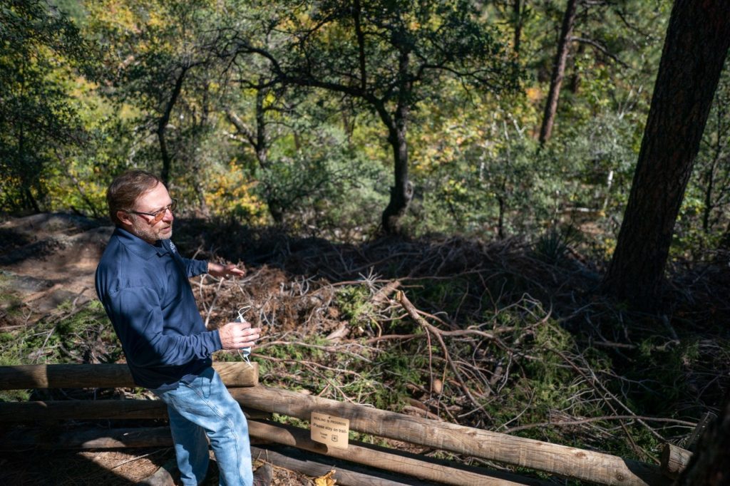
At one pullout, near Manzanita Campground, trail crews installed a low log fence that snakes along the edge of the terrace overlooking the creek below. The fence is intended to gently coax pedestrians to a good trail on the north side of the clearing, fortified with large boulders and resistant to erosion. To further discourage people from alternate routes, workers piled juniper branches on the creek side of the fence.
This is just one of the multitude of projects that trail crews completed this season up and down the canyon. At Halfway picnic area, 14 social trails have been whittled down to two.
Though the goal is to close roughly 120 social trails in the canyon, the idea of the Oak Creek Canyon Trail Rehabilitation Partnership Project isn’t to keep people from accessing the creek; it’s to put them on a better trail down to it.
“[We] want to help people do the right thing,” said Sasha Stortz, Arizona program manager for the National Forest Foundation, which helped fund and organize the recent trail work, along with Coconino National Forest and the Arizona Department of Environmental Quality. “Most people want to do the right thing.”
Everett England, a crew member with Arizona Conservation Corps, said that the Oak Creek Canyon project felt like the most impactful project he’s worked on out of the nine he’s done with the organization. None of the other trails he’s helped improve receive such a high volume of use and make such an immediate difference in the flow of people, he said.
ADEQ Senior Environmental Scientist Ron Tiller said a survey identified 320 social trails in Oak Creek Canyon in the 12-mile stretch between Midgley Bridge and Pumphouse Wash.
At pullouts, there was typically one trail down to the creek for every two car lengths, and “every place there’s a picnic table, there was a trail to the creek,” Tiller said.
All of these ad hoc trails are bad for the water quality, according to Tiller. The multitude of trails wash dirt into the creek faster than it would if it happened naturally, he said, increasing the amount of sediment that flows into the water and eroding the bank. The trails also increase the amount of trash left at the creekside, which attracts nuisance animals. All of this, the erosion and the animals, increases the level of E. coli in the water, which is a hazard to people, and is also used as an indicator of other harmful species.
The social trails can also lead to more immediate bodily harm than pathogens like E. coli. Oak Creek Canyon was the top source of backcountry emergencies for Sedona Fire District between 2017 and 2021 in recent data compiled by the district.
Blake Hourigan, assistant manager of Slide Rock State Park, said that a large number of those injuries occurred when people were scrambling down to the creek from the roadside.
In one memorable incident in August 2019, a man climbing a steep hillside near Slide Rock loosened a boulder weighing several hundred pounds. It crushed the man’s hand as it rolled down to the creekbed, where it nearly struck a baby, Hourigan said.
A week later, an 8-year-old girl had to be rescued after falling 75 feet down a steep slope close to Slide Rock State Park.
A 2,550-foot chainlink fence has since been installed between Slide Rock State Park and State Route 89A, which Hourigan believes has reduced the number of injuries in the vicinity of Slide Rock.
“It’s been noticeably calmer,” he said.
The new fence improves safety, and also water quality, by cutting down on the usage of improvised trails.
This is the second year that crews have begun implementing trail closures and improvements, so the project was able to see how its initial work held up after one year of COVID-stimulated visitation and an active monsoon once again.
Overall, they were pleased with how well previous barriers held up, with 80% of the trails worked on last year holding up without any additional work needed.
In a few cases where the trail rehab project attempted to shut down a social trail, demand was so high in certain areas — like a place with a nice red rock overhanging a deep plunge pool — demand was just too great, so the crew decided to let a trail remain with improvements to increase sustainability.
This effort to improve the network of footpaths down to Oak Creek is one of several initiatives in an even larger cooperative effort to improve water quality in one of the state’s top recreation destinations, the Oak Creek Watershed Improvement Plan. Other projects completed or underway include installing new toilets, trash cans and pet waste stations, and closing unauthorized parking spaces along State Route 89.
Tiller said there’s not enough data yet to say whether the partnership’s efforts are impacting E. coli levels in the creek, but the early signs are promising. He said he only detected four exceedances of acceptable E. coli levels this summer, which is impressive considering there was a normal monsoon season after two exceptionally dry years.
“When the creek is flowing clear, it’s been pretty good [this year],” Tiller said.


