The monsoon in Northern Arizona that officially ended Sunday, Sept. 15, is the driest in history.
“The National Climatic Data Center shows that the June to September period for Arizona was the driest on record since 1895, which is striking to me. I didn’t think it was that bad,” University of Arizona climatologist Mike Crimmins said.
Crimmins is an extension specialist at the University of Arizona Department of Environmental science. Funded by the National Oceanic and Atmospheric Administration, Crimmins is one of the principal investigators of weather data and year-to-year trends used to make forecasts for local, state and regional weather.
“The monsoon was anemic. I can’t think of any other way to describe it other than it just never had much punch to it,” Crimmins said. “Its onset was late and it really retreated with a whimper.”
Records for the monsoon track precipitation levels from June 15 to Sept. 15. Rainfall totals are the key to ranking monsoons year to year.
“The monsoon is a peculiar weather phenomenon in that it’s completely driven by available moisture and topography. The high country typically generates thunderstorms, typically in the afternoon hours and those storms move off the mountains and move into the valleys,” Crimmins said.
Flagstaff rainfall is the best indicator of the Verde Valley monsoon.
“If your higher elevation stations [Flagstaff] aren’t seeing rain, there’s very little chance that your lower elevation stations will do any better,” Crimmins said.
Flagstaff
June 15 to Sept. 15
Precipitation total
- 1.24” 2019
- 2.14” 1978
- 2.51” 1944
- 2.52” 2009
- 2.72” 1991
Source: NOAA
The Flagstaff rainfall total of 1.24 inches this year is the lowest precipitation total in history, nine-tenths of an inch lower than the previous record set in 1978. Rainfall in Sedona totalled 1.44 inches.
“It’s striking to me, especially in the high country of Northern Arizona, how few rain days there were. That to me really stands out for this monsoon,” Crimmins said.
Cottonwood
June 15 to Sept. 15
Precipitation total
- 0.32” 1936
- 0.39” 2019
- 1.73” 1973
- 2.10” 1985
- 2.81” 2007
Source: NOAA
In Cottonwood and the Verde Valley, measurements are recorded at Tuzigoot National Monument. Rainfall totals from June 15 to Sept. 15 were the second lowest on record, with just 0.39 inches of rain. “It goes back to our amazing struggles of trying to do seasonal climate prediction. We look for the output of the monsoon, as far as ranking. We are a water limited area so we focus on that,” Crimmins said.
While the wet winter may have delayed the onset of the monsoon, it is not blamed for the “nonsoon.” “Maybe it was an issue at the beginning of the summer, but it shouldn’t be a lingering issue by August. That impact should be ameliorated because it got plenty hot,” Crimmins said.
The top factor blamed for the dry monsoon by Crimmins and his climate associates is something called the Four Corners high.
“The Four Corners high really refers to that high pressure system in the atmosphere at about 15,000 feet. In your mind’s eye, that high-pressure system is centered over the Four Corners and the airflow around a high pressure system is clockwise. When it is in that position, most of Arizona is on the south side of that high, with easterly winds,” Crimmins said.
That means the airflow travels from east to west sweeping moist air upward over the hot Arizona desert up to the north. But this year the Four Corners high was too far to the south.
“The Four Corners high was just never in the right spot. It was more over Tucson, quite honestly. This explains why we had a record hot August, because the high pressure was right overhead,” Crimmins said. “That Four Corners, if it’s in the right spot, is going to take those thunderstorms that are along Mogollon Rim, and they are going to move them towards the southwest.”
Monsoon Rainfall Totals
June 15 to Sept. 15
- Sedona 1.44
- Cottonwood 1.49
- Camp Verde 1.99
- Cornville 2.33
- Clarkdale 2.13
Source: Rainlog.org
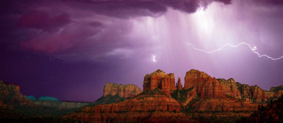
This also explains the pattern which developed in Northern Arizona in August. Dramatic lightning lit up the evening sky near Sedona on Aug. 30. But despite the dark clouds, the rain never came.
“One of the characteristics that we’ve seen with this monsoon is the upper winds have not been out of the east, but have been more out of the south or southwest. If you end up having storms that form on the Mogollon Rim, they end up getting steered off to the northeast, so they don’t end up coming downhill the way we are normally used to,” Crimmins said.
Crimmins and his associate Zach Guido at the University of Arizona Climate research department have a monthly podcast covering weather trends and topics such as the monsoon. They’ve agreed the driest summer rainfall total on record for Flagstaff led to a drier monsoon for areas south.
“When we go back to try to understand, we will look at weather maps, at atmospheric moisture, the Four Corners high not being in the right spot,” Crimmins said. “That then leads to the low average moisture in the atmosphere, especially for Northern Arizona, which then leads to below average precipitation finally as an output.”
Don Eicher can be reached at 282-7795 ext 126 or by email to deicher@larsonnewspapers.com


