


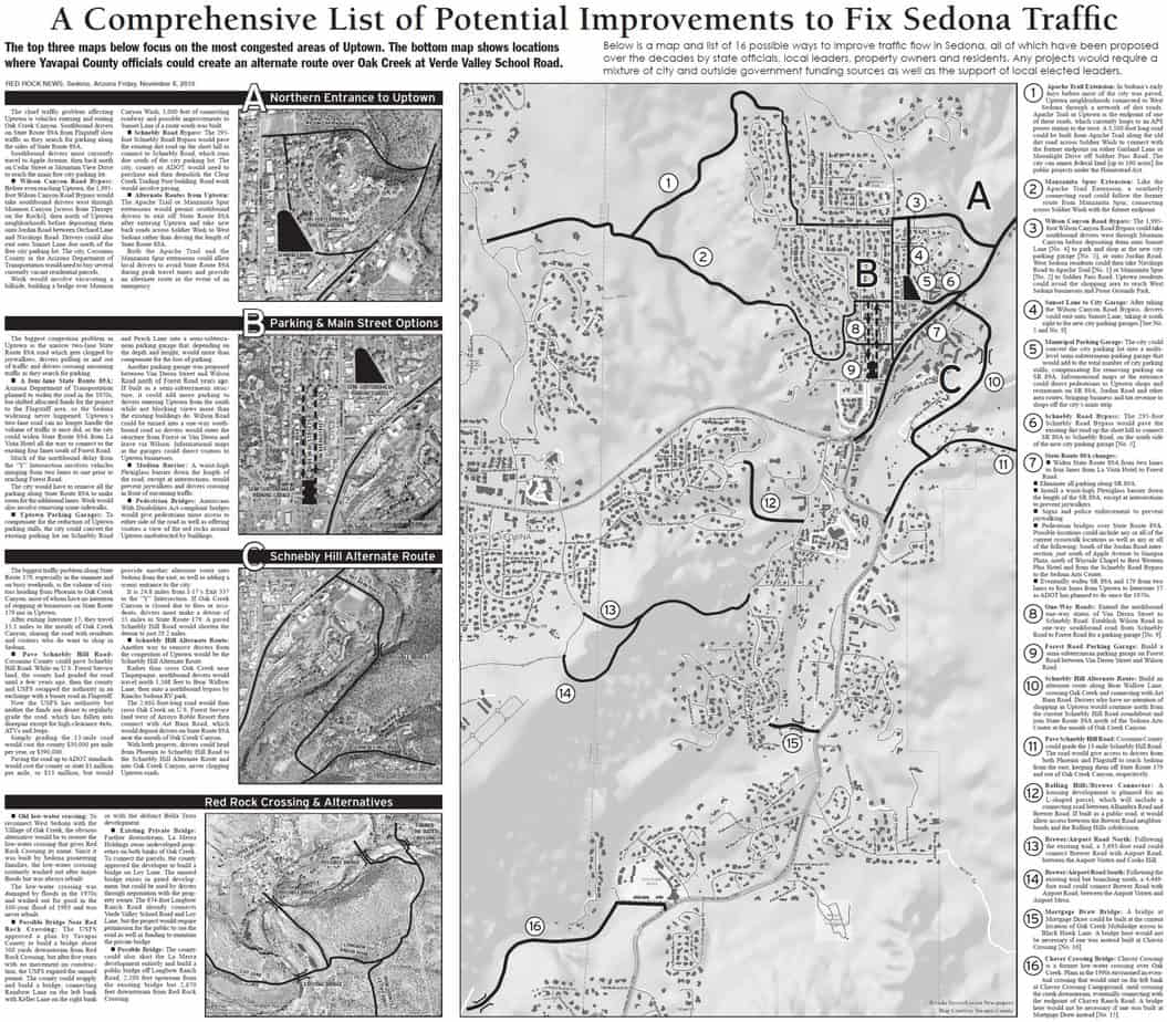
Below are five maps annotated with a list of ways to improve traffic flow in Sedona, all of which have been proposed over the decades by state officials, local leaders, property owners and residents.
Any projects would require a mixture of city and outside government funding sources as well as the support of local elected leaders.
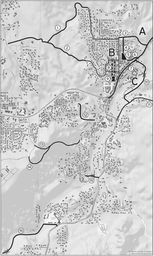
1 Apache Trail Extension: In Sedona’s early days before most of the city was paved, Uptown neighborhoods connected to West Sedona through a network of dirt roads. Apache Trail in Uptown is the endpoint of one of these roads, which currently loops to an APS power station to the west. A 3,500-foot long road could be built from Apache Trail along the old dirt road across Soldier Wash to connect with the former endpoint on either Garland Lane or Moonlight Drive off Soldier Pass Road. The city can annex federal land [up to 160 acres] for public projects under the Homestead Act.
2 Manzanita Spur Extension: Like the Apache Trail Extension, a southerly connecting road could follow the former route from Manzanita Spur, connecting across Soldier Wash with the former endpoint.
3 Wilson Canyon Road Bypass: The 1,995-foot Wilson Canyon Road Bypass could take southbound drivers west through Mormon Canyon before depositing them onto Sunset Lane [No. 4] to park and shop at the new city parking garage [No. 5], or onto Jordan Road. West Sedona residents could then take Navihopi Road to Apache Trail [No. 1] or Manzanita Spur [No. 2] to Soldier Pass Road. Uptown residents could avoid the shopping area to reach West Sedona businesses and Posse Grounds Park.
4 Sunset Lane to City Garage: After taking the Wilson Canyon Road Bypass, drivers could exit onto Sunset Lane, taking it south right to the new city parking garages [See No. 5 and No. 9].
5 Municipal Parking Garage: The city could convert the city parking lot into a multi-level semi-subterranean parking garage that would add to the total number of city parking stalls, compensating for removing parking on SR 89A. Informational maps at the entrance could direct pedestrians to Uptown shops and restaurants on SR 89A, Jordan Road and other area routes, bringing business and tax revenue to shops off the city’s main strip.
6 Schnebly Road Bypass: The 295-foot Schnebly Road Bypass would pave the existing dirt road up the short hill to connect SR 89A to Schnebly Road, on the south side of the new city parking garage [No. 5].
7 State Route 89A changes:
- Widen State Route 89A from two lanes to four lanes from La Vista Hotel to Forest Road.
- Eliminate all parking along SR 89A.
- Install a waist-high Plexiglass barrier down the length of the SR 89A, except at intersections to prevent jaywalkers.
- Signs and police enforcement to prevent jaywalking.
- Pedestrian bridges over State Route 89A. Possible locations could include any or all of the current crosswalk locations as well as any or all of the following: South of the Jordan Road intersection, just south of Apple Avenue to Sinagua Plaza, north of Wayside Chapel to Best Western Plus Hotel and from the Schnebly Road Bypass to the Sedona Arts Center.
- Eventually widen SR 89A and 179 from two lanes to four lanes from Uptown to Interstate 17 as ADOT has planned to do since the 1970s.
8 One-Way Roads: Extend the northbound one-way status of Van Deren Street to Schnebly Road. Establish Wilson Road as one-way southbound road from Schnebly Road to Forest Road for a parking garage [No. 9].
9 Forest Road Parking Garage: Build a semi-subterranean parking garage on Forest Road between Van Deren Street and Wilson Road.
10 Schnebly Hill Alternate Route: Build an alternate route along Bear Wallow Lane, crossing Oak Creek and connecting with Art Barn Road. Drivers who have no intention of shopping in Uptown would continue north from the current Schnebly Hill Road roundabout and join State Route 89A north of the Sedona Arts Center at the mouth of Oak Creek Canyon.
11 Pave Schnebly Hill Road: Coconino County could grade the 13-mile Schnebly Hill Road. The road would give access to drivers from both Phoenix and Flagstaff to reach Sedona from the east, keeping them off State Route 179 and out of Oak Creek Canyon, respectively.
12 Rolling Hills/Brewer Connector: A housing development is planned for an L-shaped parcel, which will include a connecting road between Alhambra Road and Brewer Road. If built as a public road, it would allow access between the Brewer Road neighborhoods and the Rolling Hills subdivision.
13 Brewer/Airport Road North: Following the existing trail, a 3,693-foot road could connect Brewer Road with Airport Road, between the Airport Vortex and Cooks Hill.
14 Brewer/Airport Road South: Following the existing trail but branching south, a 4,449-foot road could connect Brewer Road with Airport Road, between the Airport Vortex and Airport Mesa.
15 Mortgage Draw Bridge: A bridge at Mortgage Draw could be built at the current location of Oak Creek Mobilodge across to Black Hawk Lane. A bridge here would not be necessary if one was instead built at Chavez Crossing [No. 16].
16 Chavez Crossing Bridge: Chavez Crossing is a former low-water crossing over Oak Creek. Plans in the 1990s envisioned an eventual crossing that would start on the left bank at Chavez Crossing Campground, until crossing the creek downstream, eventually connecting with the endpoint of Chavez Ranch Road. A bridge here would not be necessary if one was built at Mortgage Draw instead [No. 15].
Map A – Northern Entrance to Uptown
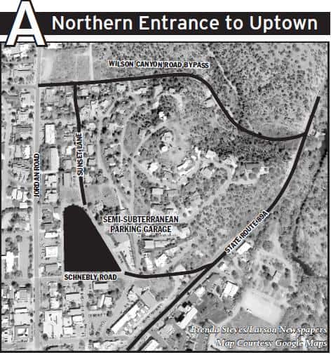
The chief traffic problem affecting Uptown is vehicles entering and exiting Oak Creek Canyon. Southbound drivers on State Route 89A from Flagstaff slow traffic as they search for parking along the sides of State Route 89A.
Southbound drivers must currently travel to Apple Avenue, then back north on Cedar Street or Mountain View Drive to reach the main free city parking lot.
Wilson Canyon Road Bypass: Before even reaching Uptown, the 1,995-foot Wilson Canyon Road Bypass would take southbound drivers west through Mormon Canyon [across from Therapy on the Rocks], then north of Uptown neighborhoods before depositing them onto Jordan Road between Orchard Lane and Navihopi Road. Drivers could also exit onto Sunset Lane due north of the free city parking lot. The city, Coconino County or the Arizona Department of Transportation would need to buy several currently vacant residential parcels.
Work would involve excavating a hillside, building a bridge over Mormon Canyon Wash, 1,000 feet of connecting roadway and possible improvements to Sunset Lane if a route south was built.
Schnebly Road Bypass: The 295-foot Schnebly Road Bypass would pave the existing dirt road up the short hill to connect to Schnebly Road, which runs due south of the city parking lot. The city, county or ADOT would need to purchase and then demolish the Clear Creek Trading Post building. Road work would involve paving.
Alternate Routes from Uptown: The Apache Trail or Manzanita Spur extensions would permit southbound drivers to exit off State Route 89A after entering Uptown and take new back roads across Soldier Wash to West Sedona rather than driving the length of State Route 89A.
Both the Apache Trail and the Manzanita Spur extensions could allow local drivers to avoid State Route 89A during peak travel times and provide an alternate route in the event of an emergency.
Map B – Parking & Main Street Options
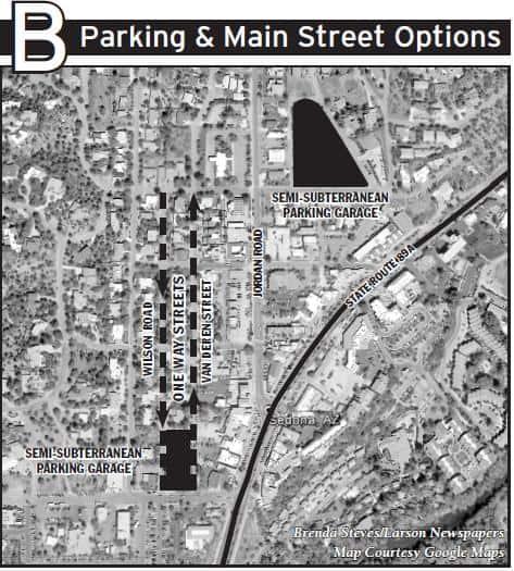
The biggest congestion problem in Uptown is the narrow two-lane State Route 89A road which gets clogged by jaywalkers, drivers pulling in and out of traffic and drivers crossing oncoming traffic as they search for parking.
A four-lane State Route 89A: Arizona Department of Transportation planned to widen the road in the 1970s, but shifted allocated funds for the project to the Flagstaff area, so the Sedona widening never happened. Uptown’s two-lane road can no longer handle the volume of traffic it once did, so the city could widen State Route 89A from La Vista Hotel all the way to connect to the existing four lanes south of Forest Road.
Much of the northbound delay from the “Y” Intersection involves vehicles merging from two lanes to one prior to reaching Forest Road.
The city would have to remove all the parking along State Route 89A to make room for the additional lanes. Work would also involve removing some sidewalks.
Uptown Parking Garages: To compensate for the reduction of Uptown parking stalls, the city could convert the existing parking lot on Schnebly Road and Peach Lane into a semi-subterranean parking garage that, depending on the depth and height, would more than compensate for the loss of parking. Another parking garage was proposed between Van Deren Street and Wilson Road north of Forest Road years ago. If built as a semi-subterranean structure, it could add more parking to drivers entering Uptown from the south while not blocking views more than the existing buildings do. Wilson Road could be turned into a one-way southbound road so drivers would enter the structure from Forest or Van Deren and leave via Wilson. Informational maps at the garages could direct visitors to Uptown businesses.
Median Barrier: A waist-high Plexiglass barrier down the length of the road, except at intersections, would prevent jaywalkers and drivers crossing in front of oncoming traffic.
Pedestrian Bridges: Americans With Disabilities Act-compliant bridges would give pedestrians more access to either side of the road as well as offering visitors a view of the red rocks around Uptown unobstructed by buildings. Possible locations could include any or all of the current crosswalk locations as well as any or all of the following: South of the Jordan Road intersection, just south of Apple Avenue to Sinagua Plaza, north of Wayside Chapel to Best Western Plus Hotel and from the Schnebly Road Bypass to the Sedona Arts Center.
Map C – Schnebly Hill Road Alternate Route
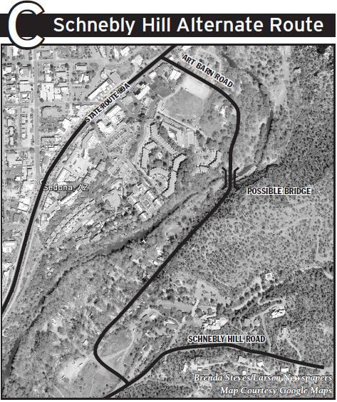
The biggest traffic problem along State Route 179, especially in the summer and on busy weekends, is the volume of visitors heading from Phoenix to Oak Creek Canyon, most of whom have no intention of stopping at businesses on State Route 179 nor in Uptown.
After exiting Interstate 17, they travel 15.1 miles to the mouth of Oak Creek Canyon, sharing the road with residents and visitors who do want to shop in Sedona.
Pave Schnebly Hill Road: Coconino County could pave Schnebly Hill Road. While on U.S. Forest Service land, the county had graded the road until a few years ago, then the county and USFS swapped the authority in an exchange with a busier road in Flagstaff.
Now the USFS has authority but neither the funds nor desire to regularly grade the road, which has fallen into disrepair except for high-clearance 4x4s, ATVs and Jeeps.
Simply grading the 13-mile road would cost the county $30,000 per mile per year, or $390,000.
Paving the road up to ADOT standards would cost the county or state $1 million per mile, or $13 million, but would provide another alternate route into Sedona from the east, as well as adding a scenic entrance to the city.
It is 24.8 miles from I-17’s Exit 337 to the “Y” Intersection. If Oak Creek Canyon is closed due to fires or accidents, drivers must make a detour of 55 miles to State Route 179. A paved Schnebly Hill Road would shorten the detour to just 29.2 miles.
Schnebly Hill Alternate Route: Another way to remove drivers from the congestion of Uptown would be the Schnebly Hill Alternate Route.
Rather than cross Oak Creek near Tlaquepaque, northbound drivers would travel north 1,368 feet to Bear Wallow Lane, then onto a northbound bypass by Rancho Sedona RV park.
The 2,661-foot-long road would then cross Oak Creek on U.S. Forest Service land west of Arroyo Roble Resort then connect with Art Barn Road, which would deposit drivers on State Route 89A near the mouth of Oak Creek Canyon.
With both projects, drivers could head from Phoenix to Schnebly Hill Road to the Schnebly Hill Alternate Route and into Oak Creek Canyon, never clogging Uptown roads.
Red Rock Crossing and Alternatives
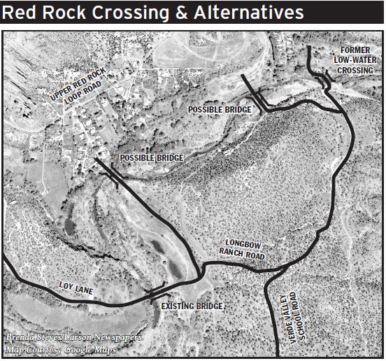
Old low-water crossing: To reconnect West Sedona with the Village of Oak Creek, the obvious alternative would be to restore the low-water crossing that gives Red Rock Crossing its name. Since it was built by Sedona pioneering families, the low-water crossing routinely washed out after major floods but was always rebuilt.
The low-water crossing was damaged by floods in the 1970s and washed out for good in the 100-year flood of 1993 and was never rebuilt.
Possible Bridge Near Red Rock Crossing: The USFS approved a plan by Yavapai County to build a bridge about 500 yards downstream from Red Rock Crossing, but after five years with no movement on construction, the USFS expired the unused permit. The county could reapply and build a bridge, connecting Rainbow Lane on the left bank with Keller Lane on the right bank or with the defunct Bella Terra development.
Existing Private Bridge: Farther downstream, La Merra Holdings owns undeveloped properties on both banks of Oak Creek. To connect the parcels, the county approved the developer to build a bridge on Loy Lane. The unused bridge exists in gated development, but could be used by drivers through negotiation with the property owner. The 874-foot Longbow Ranch Road already connects Verde Valley School Road and Loy Lane, but the project would require permission for the public to use the road as well as funding to maintain the private bridge.
Possible Bridge: The county could also skirt the La Merra development entirely and build a public bridge off Longbow Ranch Road, 2,200 feet upstream from the existing bridge but 2,670 feet downstream.
View the page as a whole below (right click view and/or download):


